
Most Popular
-
1
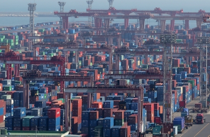
Exports to US reach all-time high, widen gap with China
-
2
Trump rekindles criticism: US forces defending 'wealthy' S. Korea 'free of charge'

-
3
[Music in drama] Rekindle a love that slipped through your fingers
![[Music in drama] Rekindle a love that slipped through your fingers](//res.heraldm.com/phpwas/restmb_idxmake.php?idx=644&simg=/content/image/2024/05/01/20240501050484_0.jpg&u=20240501151646)
-
4
S. Korea discussed possible participation in AUKUS Pillar 2 with Australia: defense minister
-
5
[New faces of Assembly] Architect behind ‘audacious initiative’ believes in denuclearized North Korea
![[New faces of Assembly] Architect behind ‘audacious initiative’ believes in denuclearized North Korea](//res.heraldm.com/phpwas/restmb_idxmake.php?idx=644&simg=/content/image/2024/05/01/20240501050627_0.jpg&u=20240502093000)


![[Music in drama] Rekindle a love that slipped through your fingers](http://res.heraldm.com/phpwas/restmb_idxmake.php?idx=644&simg=/content/image/2024/05/01/20240501050484_0.jpg&u=20240501151646)

![[New faces of Assembly] Architect behind ‘audacious initiative’ believes in denuclearized North Korea](http://res.heraldm.com/phpwas/restmb_idxmake.php?idx=644&simg=/content/image/2024/05/01/20240501050627_0.jpg&u=20240502093000)
-
6
Seoul Metro to seek legal action against malicious complaints
-
7
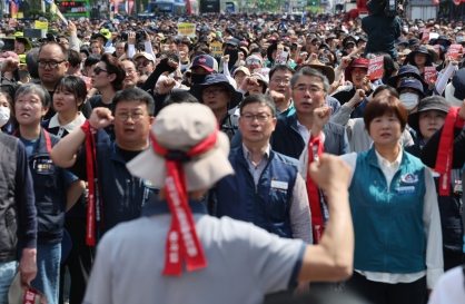
On May Day, labor unions blast Yoon's foreign nanny proposal
-
8
Illit, mired in controversy, remains on Billboard charts for 5th week

-
9
[KH Explains] Will alternative trading platform shake up Korean stock market?
![[KH Explains] Will alternative trading platform shake up Korean stock market?](//res.heraldm.com/phpwas/restmb_idxmake.php?idx=644&simg=/content/image/2024/05/01/20240501050557_0.jpg&u=20240501161906)
-
10
Opposition-led Assembly unilaterally passes bill to probe Marine's death


![[KH Explains] Will alternative trading platform shake up Korean stock market?](http://res.heraldm.com/phpwas/restmb_idxmake.php?idx=644&simg=/content/image/2024/05/01/20240501050557_0.jpg&u=20240501161906)


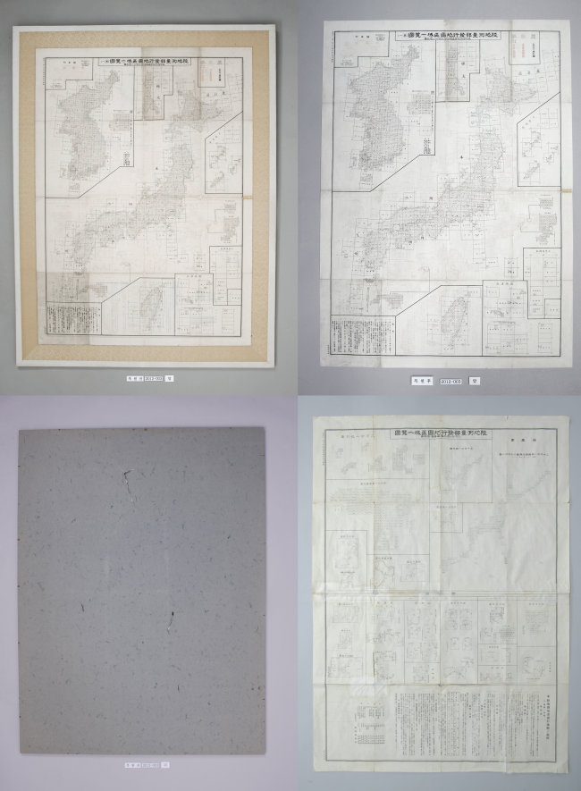
Korea’s state-run archive has restored a map made by the Japanese government in the 1930s with Dokdo marked as Korean territory, which it said would help counter the former occupier’s decades-long claim over the islets in the East Sea.
The state-run National Archives of Korea said Wednesday it has completed the five-month reconstruction of the 1936 map by using preservation films and ultrasonic waves. The Independence Hall of Korea, which commissioned the work, plans to exhibit it at its history museum in Cheonan, South Chungcheong Province.
The map played a “decisive” factor when the Allied Powers acknowledged Korea’s sovereignty over the islets following the 1945 end of World War II, historians say.
The chart displays the archipelago country and its then colonies, also including Taiwan, by region. In the Korean section, it clearly marked Dokdo and nearby Ulleung Island together and drew a bold line between Korean and Japanese territories.
The chart was produced by the cartography unit of the Japanese army, which was recognized for “the highest accuracy and credibility in Japan in terms of land survey,” according to Dokdo Center, a Seoul-based nonprofit research institute.
The piece was donated in 1988 by Lee Jong-hak, the late bibliographer and the first curator of Dokdo Museum on Ulleung Island.
Japan illegally incorporated the islets in 1905 in the lead up to its full-fledged occupation of the Korean Peninsula. Seoul retained them after its 1945 independence and mobilizes a small batch of coast guards there.
Tokyo has for decades insisted sovereignty over Dokdo via school textbooks, diplomatic and defense papers and other methods. The claim, together with the country’s repeated distortion of historical facts and failure to apologize for sex slavery and forced labor during World War II, has sparked anti-Japan protests across Korea.
By Shin Hyon-hee
(heeshin@heraldcorp.com)
<관련 한글 기사>
日정부 공식 지도에서 "독도는 한국땅"
독도가 우리나라 영토임을 분명하게 표시한 1930년대 일본 정부의 지도가 복원됐다.
이 지도는 1936년 일본 정부가 발행한 '지도구역일람도'로 제2차 세계대전 직후 연합국이 독도를 우리나라 영토로 인정하는데 결정적 역할을 한 지도다.
국가기록원은 5개월여의 작업 끝에 독립기념관이 의뢰한 '지도구역일람도'의 복원작업을 마쳤다고 24일 밝혔다.
지도구역일람도는 일본 정부의 지도제작 기관인 육군 참모본부 직속 육지측량부가 제작한 것으로, 일본과 일제의 점령지역이었던 조선과 대만, 북해도 등을 구역별로 표기하고 있다.
특히 조선구역에는 독도와 울릉도를 함께 정확히 표기하고, 조선구역과 일본구역을 구분하는 선을 굵게 그려놓아 일본 정부가 독도를 우리나라 고유 영토로 인정한 핵심적 기록 가운데 하나로 평가된다.
이 지도는 서지학자 이종학씨가 1988년 독립기념관에 기증했다.
지도구역일람도는 제작 당시 양면에 인쇄됐으나 뒷면에 종이를 덧붙여 액자를 만들어 원래의 모습을 확인할 수 없는 상태였다.
기록원은 지도 뒷면에 덧붙인 종이를 제거하고 보존용 필름 사이에 기록물을 넣고 초음파로 봉합해 원래 지도 상태로 복원했다.
독도학회 신용하 회장(울산대 석좌교수)은 "지도구역일람도는 1945년 8월 15일 일제가 패망하고 연합국이 일제 식민지를 해체할 때 독도를 우리나라 고유영토로 인정하는데 중요한 근거가 됐다"고 말했다.
한국고지도연구학회 이상태 회장은 "이 지도를 발행한 육지측량부는 일본 육군 참모본부 직속으로 일본정부의 공식기구"라면서 "일본 정부가 공식발행한 지도에 독도를 조선영토에 포함한 것은 일본이 공식적으로 독도를 우리나라 고유영토로 간주했다는 것으로 볼 수 있다"고 설명했다.
독립기념관은 지도를 조만간 전시할 예정이다.


![[Today’s K-pop] Stray Kids go gold in US with ‘Maniac’](http://res.heraldm.com/phpwas/restmb_idxmake.php?idx=642&simg=/content/image/2024/05/02/20240502050771_0.jpg&u=)