Most Popular
-
1
10-man S. Korea lose to Indonesia to miss out on Paris Olympic football qualification

-
2
Hybe-Ador feud should have limited effect on Hybe's overall performance: analysts

-
3
Second Gimpo civil servant found dead, after apologizing for not finishing work

-
4
DP leader says he will meet Yoon without conditions
-
5
First-ever meeting of president, opposition chief set to finally happen


-
6
NewJeans' singles, Japanese debut to proceed as planned, despite Hybe-Ador feud

-
7
Experts raise concerns about Japan putting pressure on Naver over Line

-
8
Blinken calls on China to press N. Korea to end its 'dangerous' behavior

-
9
Samsung mobile chief, Google device head meet in Seoul
-
10
Ship linked to NK arms shipments to Russia is moored in China: State Dept.


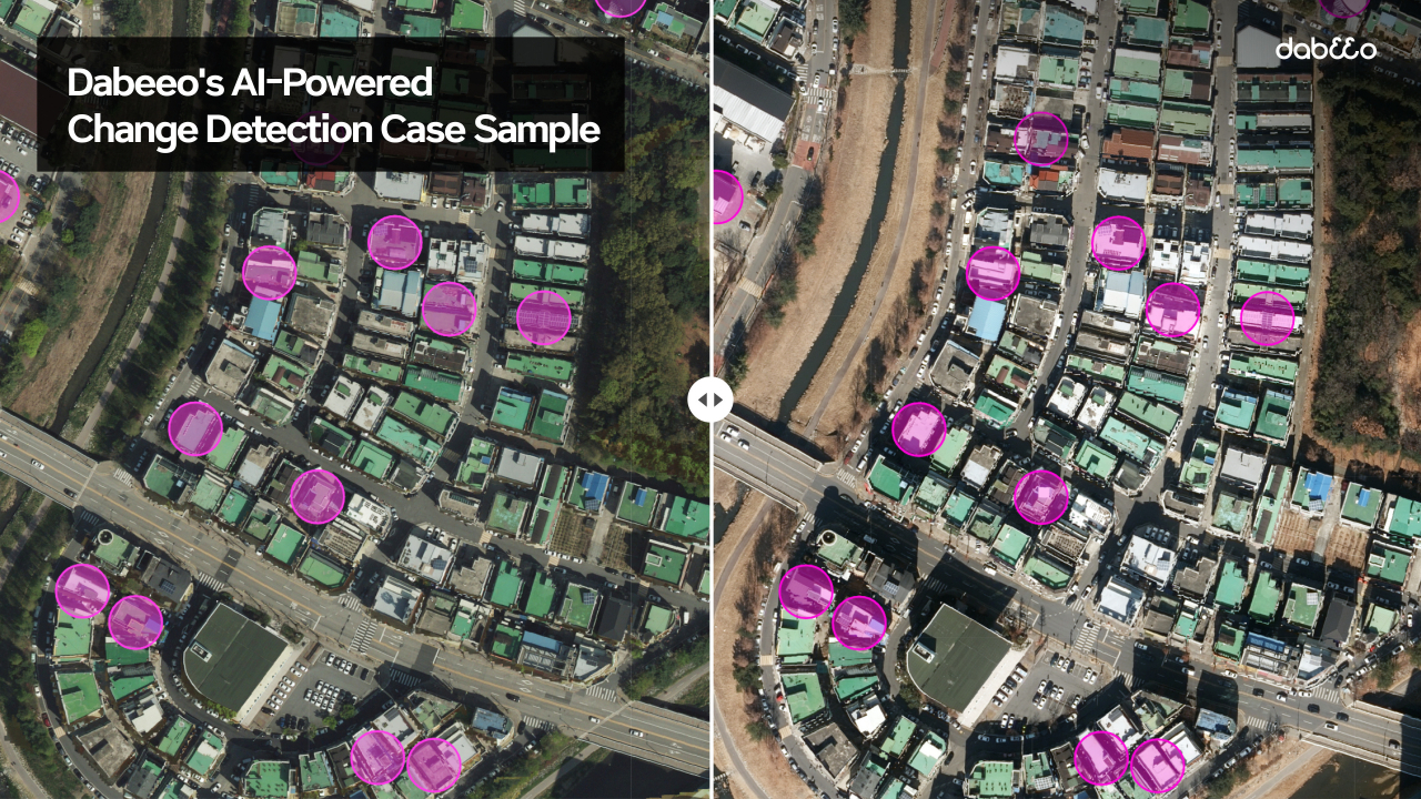
Spatial information firm Dabeeo has been chosen to participate in a government pilot project to enhance mapping here.
The AI corporation will participate in the "1:1,000 Topographic Map Enhancement" pilot project, which aims at completing more precise and accurate maps across South Korea than the current 1:5,000 maps, Dabeeo said Monday.
The pilot project is being conducted by South Korea’s National Geographic Information Institute in Seoul, Jeju Island, Yanggu-gun in Gangwon Province, Geumsan-gun in South Chungcheong Province and Gunwi-gun in North Gyeongsang Province.
While 11 companies are taking part in the project, Dabeeo is the only AI technology company among them.
Dabeeo will detect changes in buildings and roads in Geumsan and Gunwi with its AI change detection technology in the mapping project.
The company’s technology is expected to simplify cartographic processes and methodologies. The work will be done over 100 times faster at a lower cost, without causing an accuracy decline, compared to when it is done manually, according to Dabeeo.
Dabeeo has already worked on several public institutions' management tasks.
Daejeon City has used Dabeeo’s AI technology to detect changes in buildings in the city for three years. The company also has figured out trends in how endangered trees in national parks have changed.
"We will maximize our technological prowess to lead the innovation of the 1:1000 high-density electronic map project. We also plan to quickly expand into the global market, not limited to Korea," Dabeeo CEO Park Ju-hum told The Korea Herald.
-
Articles by Korea Herald