
Most Popular


-
6
[KH Explains] How should Korea adjust its trade defenses against Chinese EVs?
![[KH Explains] How should Korea adjust its trade defenses against Chinese EVs?](//res.heraldm.com/phpwas/restmb_idxmake.php?idx=644&simg=/content/image/2024/04/15/20240415050562_0.jpg&u=20240415144419)
-
7
BTS' Jungkook creates Instagram account for his dog

-
8
Korea braces for blows from Middle East conflict

-
9
Seoul says will cut power to porn festival planned on Han River

-
10
Recording of boss cursing in office ruled legal

![[KH Explains] How should Korea adjust its trade defenses against Chinese EVs?](http://res.heraldm.com/phpwas/restmb_idxmake.php?idx=644&simg=/content/image/2024/04/15/20240415050562_0.jpg&u=20240415144419)


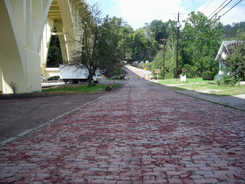
BLAINE, Ohio ― The Blaine Hill Bridge is a monument to Ohio’s past.
The 385-foot, brick-paved bridge in Belmont County is also a surviving link to the historical National Road. It dates to 1828 and is the oldest surviving bridge in the Buckeye state, designated Ohio’s Bicentennial bridge in 2003.
With its three arches and sandstone blocks, it once carried travelers on the National Road over Wheeling Creek. It is about eight miles west of Wheeling, W.Va.
Today, vehicles are banned from the bridge that lies in the shadow of the 1932-1933 bridge of steel and concrete that carries U.S. 40 over Wheeling Creek.
The Blaine Hill Bridge once took traffic west onto the Big Hill with its 20 dangerous curves. It is the longest S-shaped bridge in Ohio.
Such bridges were common on the National Road in eastern Ohio. It was easier for engineers to build bridges that were at 90-degree angles to the streams. Curved ramps were then added at both ends, creating shallow S-shaped approaches.
Pasco Drive that leads to the bridge is paved with bricks from 1917-1918.
Today the Blaine Hill Bridge is one of the biggest Ohio attractions along the National Road that some called America’s Main Street.
It ran 620 miles through six states from Maryland to Illinois. It was the only land link between the East Coast and America’s western frontier in the early 19th century, and was first envisioned by George Washington.
It was America’s first federally funded interstate highway, opening the nation to the west and serving as a corridor for moving people and goods. It was the busiest road in the United States by the 1840s, the major means of transportation until railroads were developed.
Today the National Road offers a step-back-in-time charm with sleepy pike towns, sections of old road, taverns and inns, cemeteries and more. It is, some say, an authentic experience.
It runs parallel to U.S. 40 and is a federally designated All-American Road, one of 31. That 700-mile designation stretches from Baltimore, Md., to East St. Louis, Ill.
Sites in Ohio include the boyhood home of astronaut John Glenn in New Concord, the Camp Chase Confederate cemetery and the first Wendy’s restaurant in Columbus, and the Red Brick Tavern in Lafayette that has housed six U.S. presidents.
You will also find the National Road/Zane Grey Museum at Norwich between Cambridge and Zanesville. It is operated for the Ohio Historical Society by the John and Annie Glenn Museum Foundation.
Exhibits include a 136-foot-long diorama of the National Road. It also honors writer Zane Grey (1872-1939), who hailed from nearby Zanesville and is well known for his western novels. The museum also spotlights art pottery from the area.
In Pennsylvania, the National Road runs next to the Fort Necessity National Battlefield from the French and Indian War. In West Virginia, sites include the West Virginia Independence Hall and Museum. In Illinois, travelers will find the prehistoric Cahokia Indian mounds.
The road is known for its distinctive milestones that stood at one-mile intervals along the highway.
About three feet of the exposed concrete stood above the ground. Each marker indicated the distance to Cumberland, Md., at the top center, and the name of the nearest towns to the east and west and the mile distances were carved on the sides.
The first markers of concrete weathered poorly and were replaced by sandstone in the 1850s. Concrete was used later to replace weathered milestones. Historians have identified 83 original markers still standing in Ohio, mostly in eastern counties.
In Ohio, the National Road stretches 228 miles from Bridgeport in the east on the Ohio River through Cambridge, Columbus and Springfield to the Indiana state line.
It was used in the early days by settlers heading west in Conestoga wagons. Later it was used by motorists driving cars.
Today the National Road in Ohio is almost completely intertwined with U.S. 40, built in the 1920s, and runs parallel to Interstate 70, built in the 1960s.
The National Road was authorized in 1806 by Congress. Construction began in Cumberland, Md., in 1811. It reached the Ohio River at Wheeling in 1818. Debate over the constitutionality of internal improvements delayed the road’s extension for several years.
In 1825, ground was broken in Ohio, with the National Road reaching Zanesville in 1830, Columbus in 1833 and Springfield in 1838. It stretches west to Vandalia, Ill., where money ran out.
Small towns along the National Road boomed as thousands of travelers headed west over the Allegheny Mountains to settle in Ohio and beyond.
The most common vehicles were stagecoaches that covered 60 to 70 miles per day and the colorful Conestoga wagons pulled by teams of six horses that averaged 15 miles a day.
Small towns along the road contained taverns, blacksmith shops and livery stables. There was one tavern for every mile of the National Road, according to some estimates.
So-called stagecoach taverns were more expensive, catering to affluent travelers. The Mount Washington Tavern from 1828 in southwest Pennsylvania was one stagecoach tavern that is still standing. Wagon stands were cheaper, more like modern truck stops.
In eastern Guernsey County, you can drive across one of the S-shaped bridges on the National Road. The Salt Fork Bridge from 1828 lies east of Old Washington at Bridgewater and Blend roads. It is one of two S-shaped bridges in Guernsey County and a National Historic Landmark.
Nearby is the Creighton House at Elizabethtown. It is one of the few surviving wagon and drover stands.
Drovers bought cattle, sheep or hogs from farmers and drove them on foot to Eastern markets. At night, they drove the livestock into drove-lots to be fed. The space was shared with teamsters driving freight in Conestoga wagons.
The drovers typically paid farmers a few cents a pound for hogs and cattle and $1 or $2 for fat sheep. They would drive 200 animals at a time.
Outside St. Clairsville, you will find the remains of the Brick Tavern. It featured a two-story porch and a large wooden awning or stand to shelter wagons. Plans call for its restoration.
Next door is the Great Western Schoolhouse, a one-room structure from 1870 owned by Ohio University.
Tollhouses appeared on the National Road from 1835 to 1910. That’s because federal funds for maintaining the road dried up, and the states switched to tolls. They typically stood about 20 miles apart. Searight’s Tollhouse stands west of Uniontown, Pa.
Indiana and Ohio have both produced travel guides for the National Road, and they are essential to anyone wanting to know what to see and where to find it.
Ohio’s 50-page Traveler’s Guide to the Historic National Road in Ohio outlines historical, cultural and recreational attractions along the road. It was written by Glenn Harper of the Ohio Historical Society and Doug Smith, an auctioneer and a township trustee in Licking County.
It is free. To get a copy, call the Ohio Historical Society at 614-297-2300, 800-686-6124 or 614-298-2000, or download a copy from Ohio National Road Association, www.ohionationalroad.org.
By Bob Downing
(Akron Beacon Journal)
(MCT Information Services)
-
Articles by Korea Herald


![[Today’s K-pop] Stray Kids to return soon: report](http://res.heraldm.com/phpwas/restmb_idxmake.php?idx=642&simg=/content/image/2024/04/16/20240416050713_0.jpg&u=)